과학
기타
Girl Scout Patch – LiDAR
NASA Science
조회 0
Public Domain
이 매체는 공공·자유 라이선스로 본문을 직접 표시합니다.Earth Science (SG) Landing – Menu BarHome
Who We AreWho We Are
Earth Science Division (SG)
Biospheric Science Branch (SGE)
Atmospheric Science Branch (SGG)
Project Management Branch (SGP)
Airborne Science Branch (ASP)
What We Do
Research Topics
Stories
FeaturesHighlights
Publications
Science Nuggets
Awards & Recognition
Visiting Science
Contact Us
LiDAR Patch
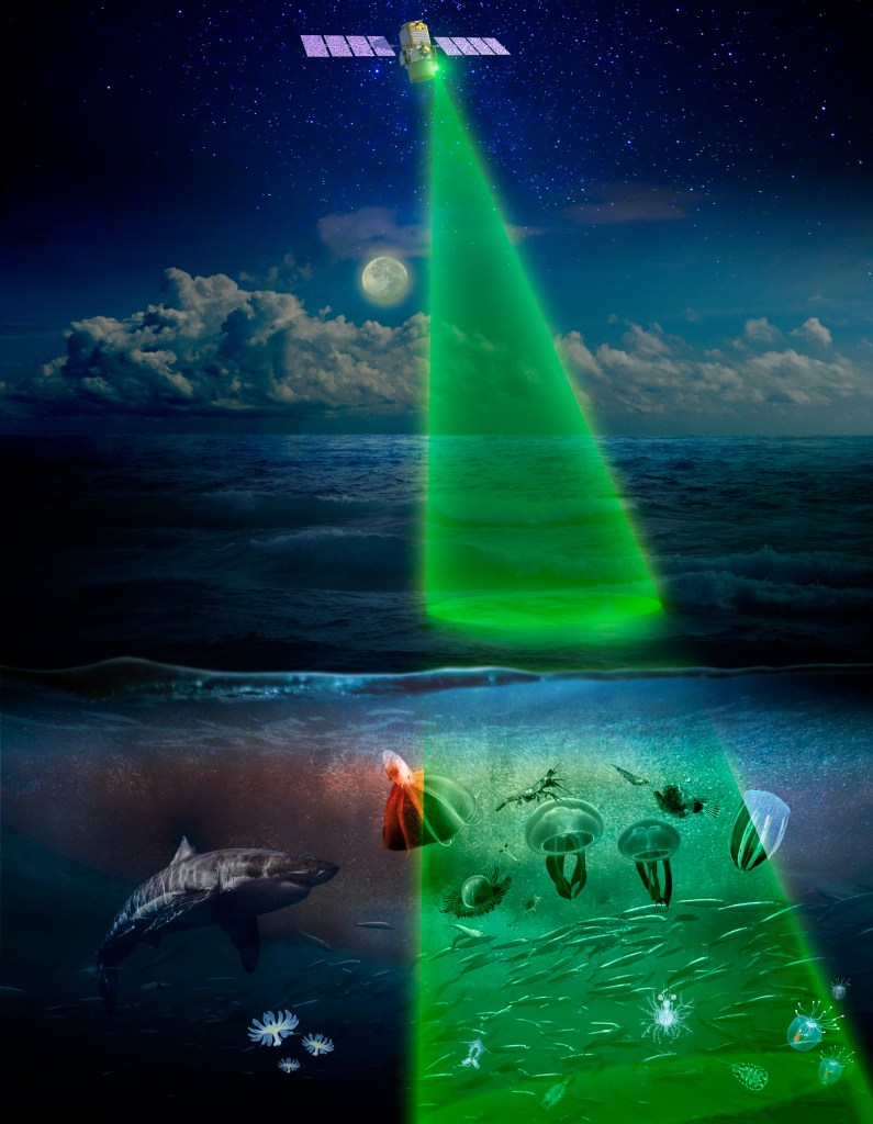
LiDAR (Light Detection and Ranging) is a technology that uses laser light to measure distances and create detailed maps of surfaces. By calculating how long it takes for light to bounce back, scientists can determine the height and shape of objects, helping them map landscapes on Earth and even explore other planets.
Get This Badge about LiDAR Patch
Age
11+
Duration
~1 hour
1. LiDAR Patch
Discover how scientists map the invisible world beneath clouds, ice, and forest canopies to undestand the shape of our planet.
1. LiDAR Patch
Resources
LiDAR Patch Activity
Click here for the LiDAR Patch activity sheet in PDF form.
Purchase the Patch
LiDAR Patch Activity
Use “laser-like” tools to map a hidden landscape just like a NASA scientist.
Create a color-coded “laser” stick
Measure the hidden landscape
Record your data and create your topographical map
Share your discoveries
What is LiDAR?
Scientists use LiDAR to create topographical maps, meaning a type of map that shows the elevation of different areas. They use this to map different parts of the Earth’s surface, like forests or cities. Some types of LiDAR can see through water, which allows scientists to map the ocean floor!
How do scientists use LiDAR?
Scientists use LiDAR to create topographical maps, meaning a type of map that shows the elevation of different areas. They use this to map different parts of the Earth’s surface, like forests or cities. Some types of LiDAR can see through water, which allows scientists to map the ocean floor!
Scientists also use LiDAR in outer space, to create maps of other planets and moons.
Keep Exploring
Discover More Girl Scout Patches
Girl Scout Patch – OWWL
Girl Scout Patch – Color-a-Pixel
Girl Scout Patch – LiDAR
Girl Scout Patch – NeMO-Net
The post Girl Scout Patch – LiDAR appeared first on NASA Science.
이 뉴스, 독자들은 어떻게 느꼈나요?
첫 반응을 남겨보세요로그인하면 감정 반응에 참여할 수 있어요.
관련 뉴스
관련 뉴스 제보는 로그인 후 가능합니다.