과학
기타
Tropical Storm Arthur
NASA General Feed
조회 0
Public Domain
이 매체는 공공·자유 라이선스로 본문을 직접 표시합니다.Earth Observatory
Science
Earth Observatory
Tropical Storm Arthur
Earth
Earth Observatory
Image of the Day
EO Explorer
Topics
All Topics
Atmosphere
Land
Heat & Radiation
Life on Earth
Human Dimensions
Natural Events
Oceans
Remote Sensing Technology
Snow & Ice
Water
More Content
Collections
Global Maps
World of Change
Articles
Earth Matters Blog
Blue Marble: Next Generation
EO Kids
Mission: Biomes
About
About Us
Subscribe
🛜 RSS
Contact Us
Search
Natural color
brightness temperature
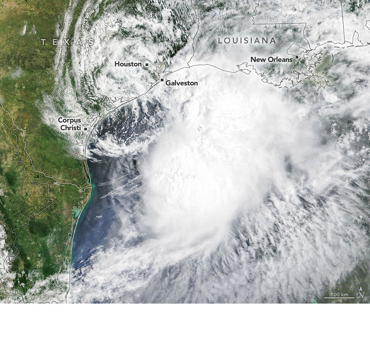
Tropical Storm Arthur’s white storm clouds cover the waters off the U.S. Gulf Coast. Some clouds extend inland over parts of Texas and Louisiana.
NASA Earth Observatory/Michala Garrison
White and purple areas of cloud off the Gulf Coast indicate the cooler areas of cloud tops associated with Tropical Storm Arthur.
NASA Earth Observatory/Michala Garrison
Natural colorbrightness temperature
Tropical Storm Arthur’s white storm clouds cover the waters off the U.S. Gulf Coast. Some clouds extend inland over parts of Texas and Louisiana.
NASA Earth Observatory/Michala Garrison
White and purple areas of cloud off the Gulf Coast indicate the cooler areas of cloud tops associated with Tropical Storm Arthur.
NASA Earth Observatory/Michala Garrison
Natural color
brightness temperature
CurtainToggle2-Up
Image Details
Images from the MODIS (Moderate Resolution Imaging Spectroradiometer) on NASA’s Terra satellite show Tropical Storm Arthur on the morning of June 17, 2026. The left image is natural color; the right shows infrared signals known as brightness temperature. NASA Earth Observatory images by Michala Garrison.
Tropical Storm Arthur, the first named storm of the 2026 Atlantic hurricane season, brought high winds and heavy rain to the U.S. Gulf Coast in mid-June.
NASA’s Terra satellite captured this natural-color image (left) at 10:30 a.m. Central Time (15:30 Universal Time) on June 17. The second image (right) depicts infrared signals known as brightness temperature, which help distinguish cooler cloud tops (white and purple) from the warmer surface below (yellow and orange). Around the time these images were acquired, the system had just recently been designated a tropical storm, according to the National Hurricane Center (NHC).
Though Arthur stayed below hurricane strength, it still delivered strong winds to parts of the Gulf Coast as it tracked northeast. The storm had maximum sustained winds of 40 miles (65 kilometers) per hour around the time these images were captured. Tropical-storm-force winds extended 175 miles (280 kilometers) from the storm’s center, the NHC reported. Measurements at Galveston, Texas, for instance, showed a gust of 48 miles per hour.
The storm also produced heavy rainfall that the National Weather Service warned could lead to life-threatening flash flooding. Estimates from IMERG (the Integrated Multi-Satellite Retrievals for GPM), a product of the GPM (Global Precipitation Measurement) mission, showed high rainfall rates over Gulf waters and extending inland on June 17.
As Arthur weakened and became less organized, it continued to bring abundant moisture to central Gulf Coast states on June 18. The National Weather Service reported rainfall rates of 3 inches (7.6 centimeters) per hour in southeastern Louisiana. Forecasts indicated that storm-total rainfall amounts could exceed 12 inches (30 centimeters) in areas, with some locations seeing totals approaching 20 inches (51 centimeters).
NASA Earth Observatory images by Michala Garrison, using MODIS data from NASA EOSDIS LANCE and GIBS/Worldview. Story by Kathryn Hansen.
Downloads
June 17, 2026: Natural color
JPEG (2.94 MB)
June 17, 2026: Brightness temperature
JPEG (2.51 MB)
References & Resources
National Hurricane Center (2026, June 17) Tropical Storm ARTHUR Advisory Archive. Accessed June 18, 2026.
National Public Radio (2026, June 17) Tropical Storm Arthur is the first named storm of the Atlantic hurricane season. Accessed June 18, 2026.
National Weather Service, Office of Water Prediction (2026, June 18) Experimental: Tropical Flood Hazard Outlook Product Archive. Accessed June 18, 2026.
You may also be interested in:
Stay up-to-date with the latest content from NASA as we explore the universe and discover more about our home planet.
Typhoon Jangmi
2 min read
The sprawling storm promised to deliver torrential rain across a wide swath of southern Japan.
Article
Tropical Cyclone Narelle Crosses Australia
3 min read
The powerful storm lashed the northern edge of the continent with damaging winds and drenching rain as it made landfall…
Article
Super Typhoon Sinlaku
3 min read
The violent storm aimed at the U.S. Northern Mariana Islands and Guam in mid-April 2026.
Article
1
2
3
4
Next
Keep Exploring
Discover More from NASA Earth Science
Subscribe to Earth Observatory Newsletters
Subscribe to the Earth Observatory and get the Earth in your inbox.
Earth Observatory Image of the Day
NASA’s Earth Observatory brings you the Earth, every day, with in-depth stories and stunning imagery.
Explore Earth Science
Earth Science Data
Open access to NASA’s archive of Earth science data
이 뉴스, 독자들은 어떻게 느꼈나요?
첫 반응을 남겨보세요로그인하면 감정 반응에 참여할 수 있어요.
관련 뉴스
1건 · 1개 매체진보 성향 100%
1개 매체
관련 뉴스 제보는 로그인 후 가능합니다.