과학
기타
Hazard Detection Lidar System Goes to the Moon
NASA Science
조회 0
Public Domain
이 매체는 공공·자유 라이선스로 본문을 직접 표시합니다.STMD Flight OpportunitiesHome
Transitions of Flight Tested…
Hazard Detection Lidar System…
Home
About
News
Work with UsAccess Flight Tests
Flight Providers
ResourcesOverview
Community of Practice Webinars
Lessons Learned Library
Newsletters
Reports and Fact Sheets
Solicitations Archives
Tech PortfolioTechnologies
Flight Summaries
Tech Transitions
Images
Hazard Detection Lidar System Goes to the Moon
A flight testing success story
Enabling landers to autonomously identify the safest sites to touch down
Moon craters and their surrounding areas are high-value destinations for lunar missions since they may contain important resources and valuable science targets. However, these sites are also home to dangers such as steep slopes that are difficult to see in the challenging lighting conditions. As a result, selecting landing sites on lunar surfaces is a critical component for NASA’s CLPS (Commercial Lunar Payload Services) missions. A new technology tested through NASA’s Flight Opportunities program is set to go to the Moon and help provide a safe and precise landing.
Astrobotic Technology’s Hazard Detection (HD) Lidar system scans and analyzes the terrain in real-time, enabling landers to autonomously map and select the safest landing sites. Lidar stands for light detection and ranging. The Pittsburgh-headquartered company will use its HD Lidar system when its Griffin lunar lander delivers science and technology payloads to the Moon during its CLPS delivery to the lunar south pole.
With Flight Opportunities support, Astrobotic first tested an engineering model of its advanced HD Lidar sensor in November 2024, confirming its ability to select a safe landing site by detecting and avoiding slopes, rough areas, and potential hazards. This flight test provided the Astrobotic team valuable data on the system’s performance, which was later leveraged by a second flight test in March 2026 with an integrated hazard detection and guidance, navigation, and control (GNC) system to further validate the system ahead of its first lunar mission scheduled for later this year. These flight tests helped the company advance the technology for use on its CLPS mission.
Preparing for Griffin Mission One | Flight testing lidar hazard detection video | Additional information
Preparing for Griffin Mission One
The Astrobotic Griffin Mission One will launch aboard a SpaceX Falcon Heavy rocket from Launch Complex 39A at NASA’s Kennedy Space Center in Florida to deliver NASA payloads to the lunar south pole.
Astrobotic’s HD Lidar system is designed to detect hazards as small as 5.9 inches (15 cm) and slopes greater than 10° to identify potential hazards, such as craters or large rocks. During the lander’s final descent phase, the spacecraft performs a stationary hover at an altitude of 100 meters — about the height of a 30-story building — while pointing its lidar toward the intended landing site. During the hover, the lidar scans the terrain, applies motion correction to account for changes in the spacecraft’s position and attitude, and processes the results into a hazard map used to identify the safest available landing location. The spacecraft then maneuvers to the selected landing site and proceeds with touchdown.
Astrobotic’s HD Lidar system works in tandem with its terrain relative navigation (TRN) sensor system, which takes live photos of the surface and compares them to an onboard map derived from orbital images to determine the spacecraft’s location above the lunar surface. In preparation for the CLPS mission, Astrobotic fully integrated its HD Lidar and TRN camera into its Griffin lander and demonstrated a successful soft landing simulation using Astrobotic’s Griffin Mission One production flatsat — a platform built with engineering models of the actual flight avionics.
Learn more about the Griffin Mission One CLPS delivery about Preparing for Griffin Mission One
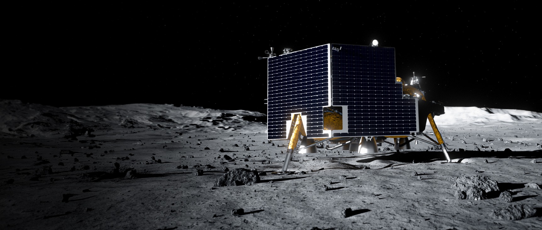
Astrobotic’s Griffin lunar lander inside the company’s integration facility. The lander uses Hazard Detection Lidar technology tested with support of NASA’s Flight Opportunities program.
Astrobotic
Advancing Hazard Detection Lidar Through Flight Testing
NASA’s Flight Opportunities program supported testing of Astrobotic’s HD Lidar as part of its mission to demonstrate promising technologies for space exploration, scientific discovery, and the expansion of space commerce. During the flight test on Nov. 11, 2024, an engineering model of the HD Lidar sensor successfully collected data over Astrobotic’s Lunar Surface Proving Ground while mounted on the company’s Xodiac reusable vertical takeoff vertical landing rocket. During the flight, the HD Lidar system processed the 3D lidar point cloud data into a terrain hazard map and helped verify lidar communications, settings, and controls under relevant conditions.
This flight test enabled Astrobotic to make a significant advancement in demonstrating space exploration technology capabilities, and the company applied lessons from this test directly to its lunar lander missions.
Learn more about the HD Lidar 2024 flight test
Additional Information
CLPS Flight: Astrobotic Griffin-1
More about this CLPS mission
Moon Missions for Flight-Tested Doppler Lidar
Read about this flight test
Commercial Lunar Payload Services Blog
Read the CLPS blog
NASA Tests New Ways to Stick the Landing in Challenging Terrain
Read about these flight tests
Moon Craters
Learn about Moon craters
Flight test planning using simulated scans from Xodiac historical flight data and Lidar Hazard Detection scan settings in simulation.
Astrobotic
The Hazard Detection Lidar payload, as integrated on the top of Xodiac. The lidar is the box on the left pointed down towards the ground; This pointing angle enables it to view the surface of the Lunar Surface Proving Ground during the flight test.
Astrobotic
Astrobotic’s Griffin lunar lander is seen inside the company’s integration facility.
Astrobotic
Learn More About Flight Opportunities
More Technology Transitions
Learn about other technologies that have advanced their readiness through testing with Flight Opportunities.
Access Flight Testing
Learn more about how to flight test your technology, instrument, or experiment with the Flight Opportunities program.
Flight Providers
Learn about the commercial flight providers that engage with the Flight Opportunities program.
Keep Exploring
Discover More Topics From NASA
Space Technology Mission Directorate
Flight Opportunities
Armstrong Flight Research Center
Commercial Lunar Payload Services (CLPS)
The goal of the CLPS project is to enable rapid, frequent, and affordable access to the lunar surface by helping…
The post Hazard Detection Lidar System Goes to the Moon appeared first on NASA Science.
이 뉴스, 독자들은 어떻게 느꼈나요?
첫 반응을 남겨보세요로그인하면 감정 반응에 참여할 수 있어요.
관련 뉴스
관련 뉴스 제보는 로그인 후 가능합니다.