Weather pattern El Nino has begun, says US agency NOAA
AI Summary
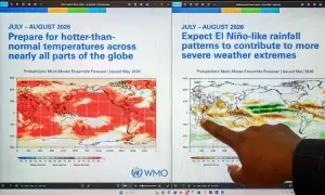
The US National Oceanic and Atmospheric Administration announced on June 11 that El Niño has officially begun in the tropical Pacific Ocean. Scientists expect it could develop into one of the strongest El Niño events on record this century, with forecasters placing a 63% probability on exceptionally strong conditions through early 2027, potentially rivaling or exceeding the 1997 record event. The phenomenon is anticipated to intensify through year-end and cause significant global disruptions including extreme temperatures, altered precipitation patterns, and impacts on food security in vulnerable regions.
Progressive: Progressive-leaning outlets employ dramatic language such as 'Super' El Niño and 'Godzilla,' framing the event as a dangerous acceleration of the fossil fuel-driven climate crisis and emphasizing scientists' fears of rapid intensification with dire consequences.
Moderate: Centrist outlets provide balanced, factual reporting of NOAA's announcement and scientific forecasts, including specific probabilities and historical comparisons, while addressing potential regional and sectoral impacts with measured language.
Conservative: Conservative-leaning outlets report the announcement and expected impacts factually, conveying the seriousness of the strong El Niño through straightforward description without sensationalist language or emphasis on alarm.
The weather phenomenon El Nino has arrived, the US National Oceanic and Atmospheric Administration (NOAA) said Thursday, and scientists expect it will intensify into the end of the year, potentially to historic strength.
El Nino is a natural climate phenomenon that warms surface temperatures in the central and eastern equatorial Pacific Ocean, bringing worldwide changes in winds, rainfall patterns and erratic weather.
And scientists fear it will exacerbate the heat of a planet already warming from burning fossil fuels, while amping up weather extremes.
In its latest advisory NOAA scientists said “El Nino conditions developed over the past month” as shown by those above-average sea surface temperatures in the Pacific.
“There is a 63 per cent chance of a very strong El Nino during November-January that would rank among the largest El Nino events in the historical record going back to 1950,” the advisory read.
Every El Nino is different, but major events often follow familiar patterns. This includes drought across parts of the Amazon, Indonesia and Australia, disrupted monsoons in India and shifting rainfall throughout the tropics.
It typically takes place every two to seven years and lasts around nine to 12 months.
El Nino tends to peak late in the year but heat in the oceans releases more slowly into the atmosphere, pushing up global temperatures the following year.
‘Deadly siren’
Europe’s Copernicus Climate Change Service on Wednesday said global forecasters were increasingly confident that a very strong El Nino warming weather pattern could form later this year.
“The odds are strongly in favour of a moderate to strong, or probably strong to record-breaking, event at this stage,” the service’s director Carlo Buontempo told AFP.
In response to NOAA’s forecast, Mohamed Adow, Director of the Nairobi-based climate and energy think tank Power Shift Africa, said for millions of people across the globe “it’s not just another weather forecast” but a “deadly siren to be feared.”
“It means failed rains, dying crops, rising food prices, and families pushed to the edge yet again.”
Earlier this month, United Nations chief Antonio Guterres urged the world to treat the likely intense incoming weather “as the urgent climate warning it is.”
“El Nino conditions will pour fuel on the fire of a warming world,” he said.
“The only effective response is climate action equal to the crisis — ending the addiction to fossil fuels, accelerating the shift to renewables, protecting the most vulnerable and delivering early warning systems for all.” ...
이 뉴스, 독자들은 어떻게 느꼈나요?
첫 반응을 남겨보세요로그인하면 감정 반응에 참여할 수 있어요.