과학
기타
Pumice Rafts Encroach on Admiralty Islands
NASA Science
조회 0
Public Domain
이 매체는 공공·자유 라이선스로 본문을 직접 표시합니다.Earth ObservatoryScience
Earth Observatory
Pumice Rafts Encroach on…
Earth
Earth Observatory
Image of the Day
EO Explorer
TopicsAll Topics
Atmosphere
Land
Heat & Radiation
Life on Earth
Human Dimensions
Natural Events
Oceans
Remote Sensing Technology
Snow & Ice
Water
More ContentCollections
Global Maps
World of Change
Articles
Earth Matters Blog
Blue Marble: Next Generation
EO Kids
Mission: Biomes
AboutAbout Us
Subscribe
🛜 RSS
Contact Us
Search
June 4, 2026
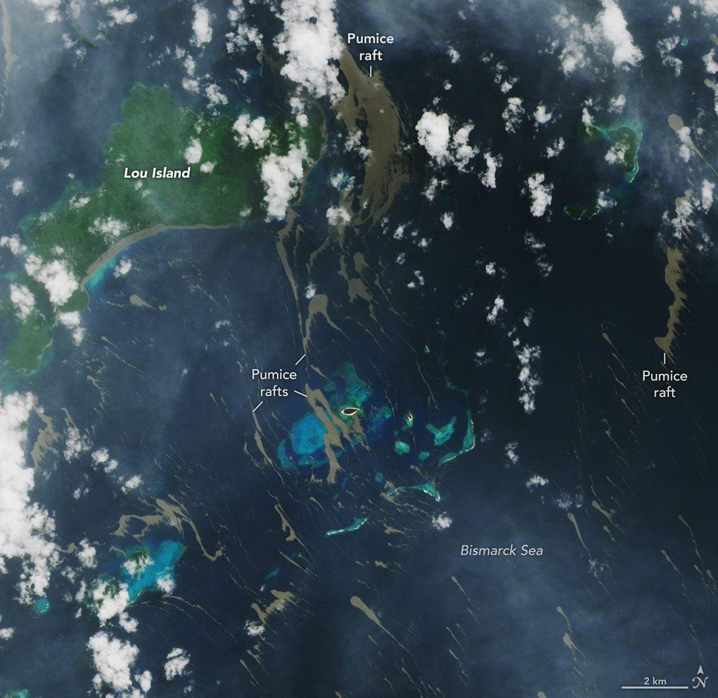
On May 8, 2026, satellites detected signs of an unexpected submarine volcanic eruption in the Bismarck Sea near the islands of Papua New Guinea. Over the next several weeks, plumes of steam and ash streamed over the sea, and areas of discolored water surrounded the eruption site. Relatively little is known about the ocean floor in this area or the volcanic feature that is presently erupting. But experts think the new activity, ongoing as of mid-June, might be occurring along the Titan Ridge and has the potential to form an ephemeral new island.
Despite the unknowns, the effects of the eruption became unmistakable for some communities in Papua New Guinea’s Admiralty Islands. In early June, rafts of pumice drifted northwest from the eruption site and clogged up coastlines on several of the islands. Bands of the buoyant volcanic material are visible in this image, acquired with the OLI (Operational Land Imager) on Landsat 8 on June 4, as they drifted with surface currents on the Bismarck Sea.
Several days after the image, news outlets reported acute impacts from thick masses of pumice reaching coastal areas. Communities on Lou Island and Baluan Island, to the south, were described by officials as among the worst affected, according to reports from local media. Outlets reported that a layer of pumice up to several meters thick blanketed the shore, cutting off access to the water. The volcanic fragments similarly choked the coast and key waterways around the much larger Manus Island, about 125 kilometers (80 miles) northwest of the volcano and out of frame.
A submarine volcano produces a plume of discolored water and vents steam into the air in an image acquired on June 4, 2026, with the OLI (Operational Land Imager) on Landsat 8. Pumice is visible near the base of the plume and exhibits a thermal signature in infrared imagery.
NASA Earth Observatory/Lauren Dauphin
Studies of past pumice raft events have found that the material can remain afloat for months to years before sinking out of satellite view. Larger rafts can form with the help of ash, which serves to “weld” together fragments of the porous rock, said Jim Garvin, the chief scientist at NASA’s Goddard Space Flight Center, noting this process occurred during the 2022 eruption of Hunga Tonga-Hunga Ha‘apai. “These masses can pile up around erupting vents to protect the eruption centers and produce ephemeral new lands in some cases,” he said. When adrift, such pumice platforms can act as floating homes for marine organisms—from microalgae to bryozoans to barnacles—and enable them to disperse over long distances.
Though beneficial to life in some ways, the rafts can pose serious threats to humans and other species. Some of the larger fragments of pumice stack up to form ridges when they reach the coastlines of islands. Reports from Papua New Guinea highlight the disruptions to fishing, the transport of goods, and access to critical services that can occur when pumice accumulates along the coast.
Communities have expressed concerns over the pumice’s effects on marine ecosystems, as well. Researchers have noted that the sustained presence of pumice can block sunlight and may inhibit photosynthesis in seagrass and corals below, and the rocks may physically damage reef structures. In a review of the ecological effects of pumice reaching Japan’s coast in 2021, researchers noted the die-off of filter-feeding fish in fishery cages from ingesting pumice, warning that other wildlife may be harmed by mistakenly consuming the rocks.
New studies using an ensemble of orbital remote sensing platforms—including Landsat, hyperspectral instruments, and imaging radars—are tracking developments in this Bismarck Sea region, Garvin said. These observations can provide new perspectives on hazards as well as unique scientific opportunities for improved understanding of submarine eruptions.
NASA Earth Observatory images by Lauren Dauphin, using Landsat data from the U.S. Geological Survey. Story by Lindsey Doermann.
Downloads
June 4, 2026
JPEG (7.36 MB)
References & Resources
ABC News (2026, June 7) Titan Ridge volcano in Papua New Guinea inundates Manus coastlines with pumice rocks. Accessed June 12, 2026.
Carn, S., via Bluesky (2026, June 2) The #BismarckSea / #TitanRidge eruption continues as of June 2. Accessed June 12, 2026.
Global Volcanism Program (2026, June 10) Titan Ridge. Accessed June 12, 2026.
He, S., et al. (2025) Pumice rafts in the global ocean: a remote sensing assessment. GIScience & Remote Sensing, 62(1).
NASA Earth Observatory (2026, May 21) New Eruption in the Bismarck Sea. Accessed June 12, 2026.
NASA Earth Observatory (2019, August 23) A Raft of Rock. Accessed June 12, 2026.
The National (2026, June 9) Manus coast facing floating pumice blockade. Accessed June 12, 2026.
Ohno, Y., et al. (2022) Coastal ecological impacts from pumice rafts. Scientific Reports, 12, 11187.
Radio New Zealand (2026, June 8) ‘This is a disaster’: Huge pumice rafts from volcano hit Manus Island coast. Accessed June 12, 2026.
You may also be interested in:
Stay up-to-date with the latest content from NASA as we explore the universe and discover more about our home planet.
New Eruption in the Bismarck Sea
5 min read
Satellite imagery shows a surge of new volcanic activity in the ocean near Papua New Guinea.
Article
Home Reef Adds On
3 min read
The Tongan volcano expanded its mid-Pacific real estate during its latest eruptive phase.
Article
Restless Kīlauea Launches Lava and Ash
3 min read
Episode 43 of the Hawaiian volcano’s current eruption was marked by high lava fountains and widespread ash dispersal.
Article
1
2
3
4
Next
Keep Exploring
Discover More from NASA Earth Science
Subscribe to Earth Observatory Newsletters
Subscribe to the Earth Observatory and get the Earth in your inbox.
Earth Observatory Image of the Day
NASA's Earth Observatory brings you the Earth, every day, with in-depth stories and stunning imagery.
Explore Earth Science
Earth Science Data
Open access to NASA’s archive of Earth science data
The post Pumice Rafts Encroach on Admiralty Islands appeared first on NASA Science.
이 뉴스, 독자들은 어떻게 느꼈나요?
첫 반응을 남겨보세요로그인하면 감정 반응에 참여할 수 있어요.
관련 뉴스
관련 뉴스 제보는 로그인 후 가능합니다.